Residential Real Estate News

Catastrophic Wildfires Devastating Tens of Billions of Dollars of Southern California Properties
Residential News » Pacific Palisades Edition | By Michael Gerrity | January 8, 2025 8:42 PM ET
Property Damage Estimated at $50 Billion and Growing
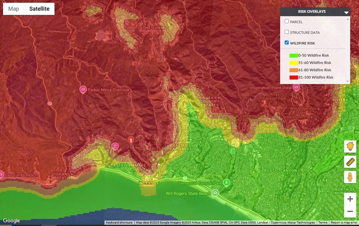
According to new data from CoreLogic, the Palisades Fire ignited on January 7, 2025 at approximately 10:30 a.m. PST in Pacific Palisades, California. Driven by fierce winds exceeding 40 mph, the fire quickly consumed around 200 acres and continued spreading at an alarming pace.
By the morning of January 8, the fire had scorched 2,921 acres, with containment efforts yielding no progress. Authorities issued evacuation orders for about 30,000 residents as multiple homes were engulfed in flames.
Early Wednesday morning, evacuation zones were extended to include parts of Malibu, compounding the challenges for a region still recovering from the Franklin Fire in December.
Strong winds and dry conditions have significantly exacerbated the situation. Wind gusts of up to 90 mph have been reported in some areas (Figure 1), marking the most extreme conditions since the 2011 windstorm in Los Angeles County.
Regional Wildfires Intensify
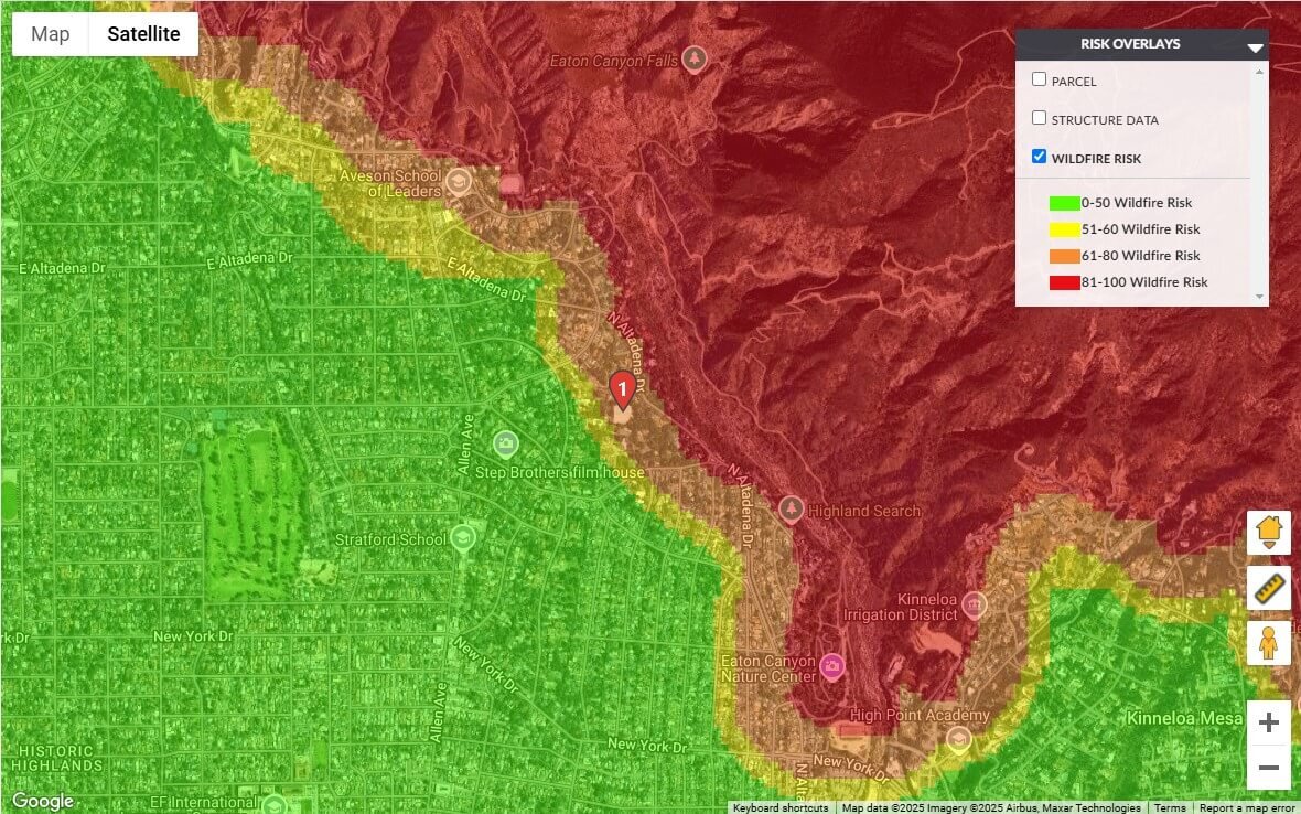
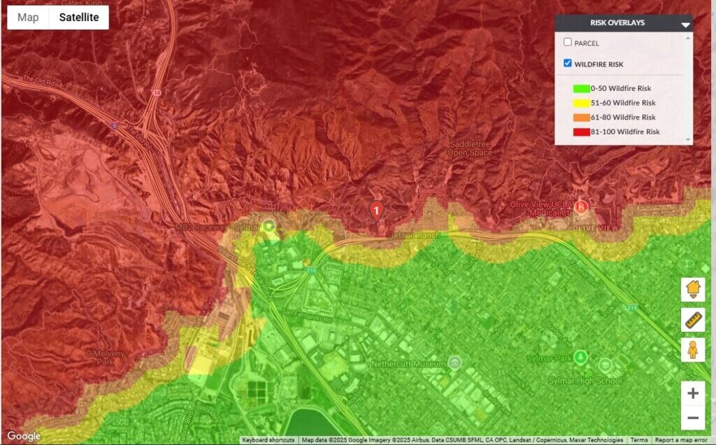
In addition to the Palisades Fire, other significant wildfires are raging across the region. The Eaton Fire in Altadena has burned 2,227 acres, while the Hurst Fire in Sylmar has consumed 505 acres. Both fires have also prompted evacuations in nearby neighborhoods.

Dr. Tom Jeffery, senior hazard scientist at CoreLogic, noted, "The Santa Ana winds driving these fires are not unusual, but their current intensity is exceptional."
All three active wildfires remain completely uncontained. While the exact number of destroyed homes is yet to be determined, numerous structures have been lost. Winds of 30-50 mph are expected to persist, grounding tanker aircraft and hindering firefighting efforts. Forecasts predict continued strong winds and single-digit relative humidity, further fueling the fires' rapid spread.
Wildfire Risk in Urban and Wildland Areas
CoreLogic estimates over 456,000 homes, valued at nearly $300 billion in reconstruction costs, face moderate or greater wildfire risk across the Los Angeles and Riverside metropolitan areas.
These figures represent the general wildfire risk within the region and are not specific to the current fires. Data specific to the ongoing events will become available once fire perimeters are clearly established.
Urban expansion has led to the growth of the wildland-urban interface (WUI), increasing fire risks where human development meets wildland areas. Effective strategies to mitigate this risk include:
- Using fire-resistant building materials.
- Maintaining defensible space around properties.
- Implementing proactive land management to reduce vegetation and fuel loads.
- Investing in emergency planning, community education, and early fire detection systems.
Conditions Driving the Palisades Fire
Dr. Jeffery explained that the area affected by the Palisades Fire had been classified as abnormally dry since early December and recently transitioned into a moderate drought within the past 10 days.
"The region has been drying steadily following late 2024 seasonal precipitation," said Dr. Jeffery. "The Santa Ana winds, with reported speeds of 50-60 mph or more, are intensifying fire activity and hindering suppression efforts by grounding tanker aircraft and helicopters."
The Palisades area has experienced several notable fires in the past, including the 2019 Palisades Fire, the 2017 Topanga Fire, and the 2021 Palisades Fire, which burned 1,203 acres in an undeveloped region north of the community.
Sign Up Free | The WPJ Weekly Newsletter
Relevant real estate news.
Actionable market intelligence.
Right to your inbox every week.
Real Estate Listings Showcase
Related News Stories
Residential Real Estate Headlines
- Las Vegas Area Home Prices Uptick 4.3 Percent Annually in March
- Single-Family Rent Growth in U.S. Trends Upward in 2025
- U.S. Mortgage Rates Tick Down Post Trump Tariffs Commencement
- President Trump's 'Liberation Day' Tariffs Potential Impact on the U.S. Housing and Mortgage Markets
- Baby Boomers Biggest Cohort of U.S. Home Buyers in 2025 as Millennials Decline
- U.S. Monthly Housing Payments Hit Record High in 2025
- U.S. Pending Home Sales Uptick in February
- Global Prime Residential Rent Slowdown Continued in Late 2024
- Ireland Home Price Inflation Hits 8 Year High in Early 2025
- Existing Home Sales in America Uptick in February
- Great Miami Area Residential Sales Decline 15 Percent Annually in February
- Mortgage Rates Uptick in Mid-March, Ending 9-Week Decline in U.S.
- World Property Ventures Builds the Future of Real Estate with New Funding Round
- U.S. Builder Sentiment Declines Amid Economic Uncertainty and Rising Costs
- Black Homeownership Rates in U.S. Enjoy Largest Annual Increase of All Racial Groups
- Wealthy Renters Are Taking Over More of the U.S. Rental Market
- If U.S. Congress Does Not Extend NFIP Soon, Thousands of Daily Home Closings Impacted
- U.S. Mortgage Applications Spike 11 Percent in Early March
- Greater Palm Beach Area Residential Sales Rise in Early 2025
- New Apartments in U.S. Are Leasing at Slowest Pace on Record
- U.S. Mortgage Rates Drop to 4 Month Low in March
- Overall U.S. Mortgage Delinquency Rates Dip in December
- New Tariffs on Canada, Mexico to Impact U.S. Homebuilder Input Costs
- Monaco's Property Market: A Tale of Two Cities
- U.S. Home Purchase Cancellations Surge, 1 in 7 Sales Getting Canceled
- U.S. Pending Home Sales Hit Historic Low in Early 2025
- Greater Miami Area Residential Sales Dip in January
- Governor DeSantis Supports Ending Property Taxes in Florida
- WPV Aims to Become the Berkshire Hathaway of Real Estate Tech
- U.S. Home Sales Slump Continues in January
- Average Americans Spend 38 Percent of Monthly Income on Mortgage Payments
- Switzerland's Safe-Haven Appeal Grows with World's Wealthy Homebuyers
- U.S. Builder Confidence Rapidly Declines in February
- Las Vegas Home Sales Rise 6.7 Percent Annually in January, Condo Sales Dip
- Homebuyer Demand in America Drops to 5-Year Low in Early 2025
- Ownership More Affordable Than Renting in Most U.S. Markets
- The World's First Global Listings Service Launches, Called a GLS
- Home Prices Continue to Rise in 89 Percent of U.S. Metros in Late 2024
- Global Luxury Residential Prices Showed Gradual Improvement in Late 2024
- U.S. Construction Hiring Rate Drops to Lowest Levels in 5 Years


